
General Information
| Completion: | 1957 |
|---|---|
| Status: | demolished (9 December 2016) |
Project Type
| Structure: |
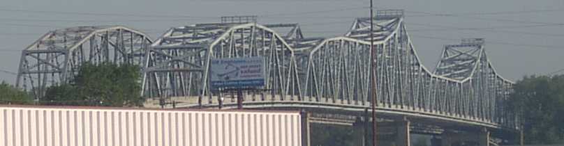
Cantilever truss bridge |
|---|---|
| Function / usage: |
Road bridge |
| Structure: |
Through truss bridge |
| Material: |
Steel bridge |
| Structure: |
Continuous truss bridge |
| Demolition method: |
Structurae Plus/Pro - Subscribe Now! |
| Material: |
Structurae Plus/Pro - Subscribe Now! |
Location
| Location: |
Kansas City, Wyandotte County, Kansas, USA Riverside, Platte County, Missouri, USA |
|---|---|
| Address: | U.S. Route 69 |
| Crossed: |
|
| Next to: |
Fairfax Bridge (1934)
|
| Coordinates: | 39° 9' 24.12" N 94° 37' 23.88" W |
Technical Information
Dimensions
| main span | 142.02 m | |
| width | 8.63 m | |
| total length | 777.91 m |
Materials
| truss |
steel
|
|---|
Participants
Currently there is no information available about persons or companies having participated in this project.
Relevant Web Sites

- About this
data sheet - Structure-ID
20030080 - Published on:
13/08/2007 - Last updated on:
11/10/2020
Structurae cooperates with


