
General Information
| Beginning of works: | 21 April 1931 |
|---|---|
| Completion: | 27 September 1934 |
| Status: | demolished (16 January 2015) |
Project Type
| Function / usage: |
Road bridge |
|---|---|
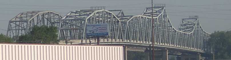
| Structure: |
Cantilever truss bridge |
| Material: |
Steel bridge |
| Structure: |
Through truss bridge |
| Demolition method: |
Structurae Plus/Pro - Subscribe Now! |
| Material: |
Structurae Plus/Pro - Subscribe Now! |
Location
| Location: |
Kansas City, Wyandotte County, Kansas, USA Riverside, Platte County, Missouri, USA |
|---|---|
| Address: | U.S. Route 69 |
| Crosses: |
|
| Next to: |
Platte Purchase Bridge (1957)
|
| Coordinates: | 39° 9' 23.58" N 94° 37' 24.76" W |
Technical Information
Dimensions
| total length | 757.9 m | |
| number of spans | 13 |
Materials
| truss |
steel
|
|---|
Excerpt from Wikipedia
The Fairfax Bridge was a truss bridge over the Missouri River that handled southbound U.S. Route 69 (US 69), connecting Interstate 635 (I-635) in Riverside, Missouri with the Seventh Street Trafficway in Fairfax, Kansas. Built by the Kansas City Bridge Company, it was 2,486.5 feet (757.9 m) long and had 13 spans on 15 piers. The bridge has now been removed, with the approach spans being demolished using explosive charges on January 16, 2015, and the main spans on January 24, 2015.
History
Ground was broken April 21, 1931, with the bridge opening on September 27, 1934 at a cost of $600,000. Originally carrying two-way traffic, it was restriped for two southbound lanes in 1957 following the opening of its sister bridge, the Platte Purchase Bridge, which handles northbound traffic. In 2013 plans were announced for replacement of both the Fairfax Bridge and the Platte Purchase Bridge. The Fairfax Bridge was scheduled for demolition first in early 2015, with the bridge closed to all traffic on October 31, 2014 and traffic routed to the Platte Purchase Bridge.
The replacement bridge was formally opened by the Missouri Department of Transportation on March 16, 2017.
Text imported from Wikipedia article "Fairfax Bridge (Missouri River)" and modified on October 19, 2020 according to the CC-BY-SA 4.0 International license.
Participants
Relevant Web Sites

- About this
data sheet - Structure-ID
20030079 - Published on:
13/08/2007 - Last updated on:
11/10/2020


