
General Information
| Completion: | 1932 |
|---|---|
| Status: | in use |
Project Type
| Function / usage: |
Hydroelectric dam / plant |
|---|---|
| Material: |
Concrete dam |
Location
| Location: |
British Columbia, Canada |
|---|---|
| Impounds: |
|
| Coordinates: | 49° 28' 4.54" N 117° 28' 2.36" W |
Technical Information
Dimensions
| height | 16 m |
Excerpt from Wikipedia
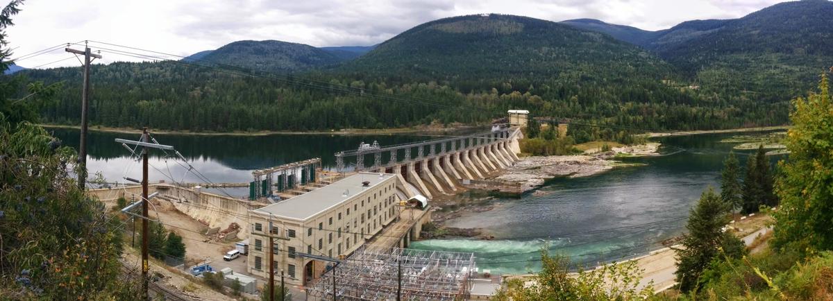
Corra Linn Dam is a concrete hydroelectric dam on the Kootenay River in the Canadian province of British Columbia. It is located where the West Arm Kootenay Lake flows into the Kootenay River. The dam's powerplant has a generating capacity of 49 MW. Water from the reservoir is diverted 4.5 km past Corra Linn by the Kootenay Canal on the left bank above the river, to the Kootenay Canal Generating Station. The dam was formerly owned by West Kootenay Power. Since 2003 it is owned by FortisBC.
History
Before the dam was built the location was the site of Corra Linn Rapids. For the six-year period after it was built, the dam was not permitted to raise the level of Kootenay Lake. It operated as a run of the river hydroelectric plant allowing the spring freshet to pass downstream. After devastating floods to Idaho farmlands in 1938, the International Joint Commission granted two approvals.
The first allowed excavation to the outlet of the lake at Grohman Narrows. In 1939 334,585 cubic yards of gravel and 17,927 cubic yards of rock was removed, this includes rock bluffs on the south side of the river. The narrows was made deeper and wider allowing for a greater drawdown of the lake during the winter and a greater flow during spring freshet. Even after excavation Grohman Narrows continues to limit outflow from the lake. During the 1961 flood the level of the lake was 3 metres above the maximum level of the dam, due to water held back at the narrows. Models indicate the lake would have been almost 2 metres higher without the excavation. Between 2005 and 2010 BC Hydro has considered more excavation at the narrows as a potential "Resource Smart" project.
The second approval permitted the dam to be used to raise the level of Kootenay Lake by 2 metres, thus forming a reservoir for flood control and hydro power.
Water levels
After the 1948 Vanport Oregon flood, the Columbia River Treaty in 1961 led to the construction of flood control dams to regulate water flowing into Kootenay Lake. Duncan Dam in 1967 and Libby Dam in 1975. The resulting constant supply of water led to the dam being bypassed by the larger, more efficient Kootenay Canal in 1976. Kootenay basin reservoirs provide nearly 7,000,000 acre feet (8.6 km³) of storage which constitutes almost half of the 15,500,000 acre feet (19.1 km³) stored in Columbia River Treaty reservoirs.
Text imported from Wikipedia article "Corra Linn Dam" and modified on July 23, 2019 according to the CC-BY-SA 4.0 International license.
Participants
Currently there is no information available about persons or companies having participated in this project.
Relevant Web Sites

- About this
data sheet - Structure-ID
20041602 - Published on:
24/12/2008 - Last updated on:
19/04/2016


