General Information
| Completion: | 21 December 1983 |
|---|---|
| Status: | in use |
Project Type
| Function / usage: |
Below grade metro or light-rail station |
|---|---|
| Structure: |
Underground structure |
Location
| Location: |
Mexico City, Distrito Federal, Mexico |
|---|---|
| Part of: | |
| Coordinates: | 19° 29' 27.96" N 99° 11' 11.21" W |
Technical Information
There currently is no technical data available.
Excerpt from Wikipedia
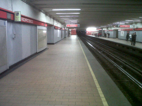
UAM-Azcapotzalco (Spanish pronunciationⓘ; formerly Azcapotzalco) is a metro station in northern Mexico City, located in the Azcapotzalco borough, along Line 6. In 2019, the station had an average ridership of 8,076 passengers per day.
General information
Azcapotzalco was opened on 21 December 1983, as part of the first stretch of Line 6, going from El Rosario to Instituto del Petróleo.
The station serves the Reynosa Tamaulipas, San Andrés and San Marcos neighborhoods. It is also close to Azcapotzalco's downtown and city hall as well as to the Universidad Autónoma Metropolitana Azcapotzalco campus.
Name and pictogram
The station was originally named Azcapotzalco. This was decided due to the fact that Metro Azcapotzalco was the closest station to downtown Azcapotzalco and to the municipality's city hall.
The station's pictogram depict an ant because Azcapotzalco's ancient meaning literally translates to "in the place of the anthills".
Text imported from Wikipedia article "UAM-Azcapotzalco metro station" and modified on December 11, 2024 according to the CC-BY-SA 4.0 International license.
Participants
Currently there is no information available about persons or companies having participated in this project.
Relevant Web Sites
- About this
data sheet - Structure-ID
20057335 - Published on:
13/08/2010 - Last updated on:
11/12/2024


