General Information
| Completion: | 1874 |
|---|---|
| Status: | in use |
Project Type
| Structure: |
Bowstring-arch-truss bridge |
|---|---|
| Function / usage: |
Road bridge |
| Material: |
Iron bridge |
| Structure: |
Through truss bridge |
| Material: |
Structurae Plus/Pro - Subscribe Now! |
| Function / usage: |
current use: Pedestrian bridge (footbridge) |
Awards and Distinctions
| 1988 |
for registered users |
|---|
Location
| Location: |
Springfield, Faulkner County, Arkansas, USA |
|---|---|
| Crosses: |
|
| Coordinates: | 35° 8' 29.80" N 92° 27' 13.36" W |
Technical Information
Dimensions
| main span | 44.50 m | |
| height | 4.575 m | |
| length | 57.34 m |
Materials
| piers |
masonry
|
|---|---|
| truss |
wrought iron
|
Excerpt from Wikipedia
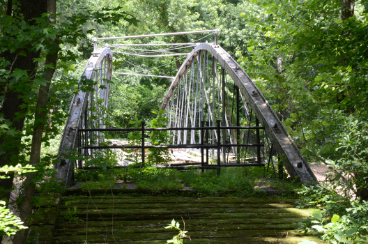
The Springfield Bridge is a historic bowstring truss bridge, located in Beaverfork Lake Park in Conway, Arkansas, USA. It originally spanned Cadron Creek in rural Faulkner County east of Springfield. It is 188 feet (57 m) long, set on stone abutments, with tubular metal top chords that rise 15 feet (4.6 m) above the bottom chords. Built circa 1871–74, it is the oldest documented highway bridge in the state and ist only documented bowstring arch bridge.
The bridge was listed on the National Register of Historic Places in 1988. In 2015, the Faulkner County Historical Society began a drive to relocate the bridge as part of a local trail network. The bridge has suffered from neglect due to ist remote location as well as damage by fire and vandalism. The bridge was moved to ist present location in 2017.
Text imported from Wikipedia article "Springfield Bridge" and modified on March 2, 2021 according to the CC-BY-SA 4.0 International license.
Participants
Relevant Web Sites
Relevant Publications
- (1984): Great American Bridges and Dams. A National Trust Guide. John Wiley & Sons, New York (USA), pp. 167-168.
- About this
data sheet - Structure-ID
20003556 - Published on:
10/06/2002 - Last updated on:
02/03/2021


