General Information
| Completion: | 9 January 1910 |
|---|---|
| Status: | in use |
Project Type
| Function / usage: |
Below grade metro or light-rail station |
|---|---|
| Structure: |
Underground structure |
Location
| Location: |
Paris ( 5th), Paris, Ile-de-France, France Paris ( 6th), Paris, Ile-de-France, France |
|---|---|
| Part of: | |
| Coordinates: | 48° 51' 12.65" N 2° 20' 36.57" E |
Technical Information
There currently is no technical data available.
Excerpt from Wikipedia
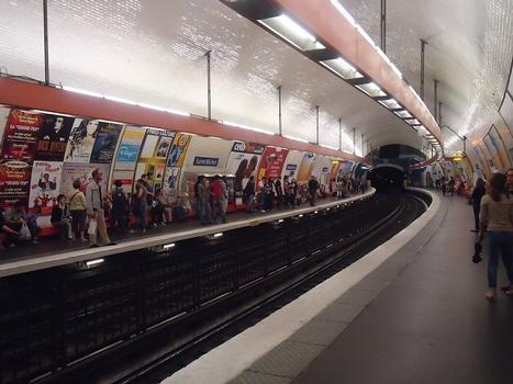
Saint-Michel is a station on Line 4 of the Paris Métro in the 5th arrondissement. Located in the Quartier Latin, it offers a connection to the St-Michel - Notre-Dame RER station on RER lines B and C.
The station was opened on 9 January 1910 as part of the connecting section of the line under the Seine between Châtelet and Raspail. It is named after the Boulevard Saint-Michel.
Architecture
Like nearby Cité station, Saint-Michel features a pioneering construction technique, made necessary by the proximity of the Seine. The station comprises three steel caissons – one for the train hall and two for access at each end – which were assembled at the surface and then lowered into place.
The platforms are 118 metres long, more than the standard length on the network.
Text imported from Wikipedia article "Saint-Michel (Paris Métro)" and modified on July 23, 2019 according to the CC-BY-SA 4.0 International license.
Participants
Currently there is no information available about persons or companies having participated in this project.
Relevant Web Sites
- About this
data sheet - Structure-ID
20051698 - Published on:
08/01/2010 - Last updated on:
10/09/2014


