
General Information
| Other name(s): | Peebles Viaduct; Queen's Bridge |
|---|---|
| Beginning of works: | 1863 |
| Completion: | 1964 |
| Status: | in use |
Project Type
| Structure: |
Semi-circular arch bridge |
|---|---|
| Material: |
Masonry bridge |
| Function / usage: |
original use: Railroad (railway) bridge current use: Pedestrian bridge (footbridge) |
Location
| Location: |
Peebles, Scottish Borders, Scotland, United Kingdom |
|---|---|
| Crosses: |
|
| Coordinates: | 55° 38' 57.13" N 3° 13' 14.21" W |
Technical Information
Dimensions
| height | 9.8 m | |
| number of spans | 8 x 9.91 m |
Excerpt from Wikipedia
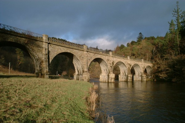
Neidpath Viaduct, occasionally known as the Queen's Bridge, consists of eight stone skew arches and was built to carry the Symington to Peebles branch line of the Caledonian Railway over the River Tweed to the south-west of Neidpath Castle. Now closed to rail traffic the bridge is used as a footpath.
History
The Symington, Biggar and Broughton Railway's extension to Peebles was authorised on 3 July 1860 but by the time construction was complete the company had been absorbed by the much larger Caledonian Railway. The bridge was designed by Robert Murray, a local engineer living in Peebles, and George Cunningham, Consultant Engineer to the Caledonian Railway, and built of sandstone ashlar blocks. All eight arches are semicircular, skewed and constructed with helical courses, crossing the Tweed obliquely with four of the piers in the water, and the whole structure is built on a graceful curve of radius 440 yards (400 m) so as to align the route with nearby Neidpath Tunnel, at the eastern end of the viaduct and to the south of Neidpath Castle. The similar but smaller Lyne Viaduct is located a little to the west and is often confused with this bridge. On 1 January 1923 ownership of the viaduct, along with the rest of the Caledonian Railway, passed to the London, Midland and Scottish Railway and thence to the Scottish region of British Railways on nationalisation in 1948. The line lost its regular passenger traffic on 5 June 1950 and closed completely on 7 June 1954 but the Category A listed structure, one of the finest examples of skew arch construction in Scotland, remains as part of a footpath, the picturesque setting being popular with ramblers.
Text imported from Wikipedia article "Neidpath Viaduct" and modified on July 23, 2019 according to the CC-BY-SA 4.0 International license.
Participants
Currently there is no information available about persons or companies having participated in this project.
Relevant Web Sites

- About this
data sheet - Structure-ID
20010133 - Published on:
02/09/2003 - Last updated on:
01/01/2017


