
General Information
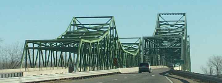
| Other name(s): | Mormon Pioneer Memorial Bridge |
|---|---|
| Completion: | 1952 |
| Status: | in use |
Project Type
| Structure: |
Cantilever truss bridge |
|---|---|
| Function / usage: |
current use: Motorway bridge / freeway bridge |
Location
| Location: |
Omaha, Douglas County, Nebraska, USA Pottawattamie County, Nebraska, USA |
|---|---|
| Address: | I-680 |
| Crosses: |
|
| Next to: |
Mormon Bridge (1979)
|
| Coordinates: | 41° 20' 44.16" N 95° 57' 25.92" W |
Technical Information
There currently is no technical data available.
Excerpt from Wikipedia
The Mormon Bridge are two cantilever bridges that cross the Missouri River connecting Pottawattamie County, Iowa with Florence in the north end of Omaha, Nebraska via Interstate 680 (Iowa-Nebraska).
About
The first bridge was finished in 1952 after an unsuccessful attempt in 1936 to build a bridge at the same site. It originally connected Nebraska Highway 36 with unsigned Iowa Highway 988. It was originally a toll bridge operated by the North Omaha Bridge Commission with $3.45 million in bonds. It was officially called the Mormon Pioneer Memorial Bridge but in common usage it has been called the Mormon Bridge and got its name because the Mormon Trail passed nearby. Spencer W. Kimball, President of The Church of Jesus Christ of Latter-day Saints (LDS Church), was the last to pay the toll on April 21, 1979 when the second bridge to the north of the original bridge was added, and it became part of the Interstate Highway System.
Text imported from Wikipedia article "Mormon Bridge (Omaha)" and modified on July 23, 2019 according to the CC-BY-SA 4.0 International license.
Participants
Currently there is no information available about persons or companies having participated in this project.
Relevant Web Sites
There currently are no relevant websites listed.
- About this
data sheet - Structure-ID
20030111 - Published on:
13/08/2007 - Last updated on:
05/02/2016


