
General Information
| Completion: | 1951 |
|---|---|
| Status: | demolished (June 2013) |
Project Type
| Structure: |
Truss arch bridge |
|---|---|
| Function / usage: |
Road bridge |
| Material: |
Steel bridge |
| Structure: |
Through arch bridge |
Location
| Location: |
Hastings, Dakota County, Minnesota, USA |
|---|---|
| Address: | U.S. Route 61 |
| Crosses: |
|
| Replaced by: |
Hastings Bridge (2013)
|
| Coordinates: | 44° 44' 47.71" N 92° 51' 9.11" W |
Technical Information
Dimensions
| main span | 156.7 m | |
| length | 567.2 m |
Materials
| truss |
steel
|
|---|
Excerpt from Wikipedia
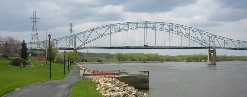
The Hastings High Bridge was a continuous steel through truss bridge that spanned the Mississippi River in Hastings, Minnesota, United States. It was designed by Sverdrup and Parcel and was built in 1951 by Graus Construction Company of Hasting for $356,000. It was demolished in late 2013 when a new bridge opened. It had been scheduled to be torn down and replaced by MNDot in 2019, but after the I-35W bridge collapse in Minneapolis, it was re-prioritized and construction started in 2010.
Condition
Following the August 1, 2007 collapse of the I-35W Mississippi River bridge, the Hastings High Bridge was inspected between August 20 and August 31, 2007. An executive summary of the inspection report was released on January 15, 2008, questioning whether the bridge was capable of sustaining its 40-ton posted capacity, and calling for a load analysis to be performed immediately. Because the existing bridge was obsolete and average daily traffic exceeded 30,000 vehicles, MnDOT accelerated the new bridge project to begin in 2010. Three design-build teams submitted proposals on June 30, 2010, and the contract was awarded to the joint venture Lunda/Ames.
In June 2013, two of the four lanes of the new bridge were open for traffic, and in November 2013 all four lanes opened. The new bridge cost $130 million and is the longest free-standing tied-arch bridge in North America, at a length of 545 feet. The main span is composed of arches, girders, beams, stringers, and roadway, offering four lanes of traffic plus twelve feet of mixed use pedestrian and bike path. The new bridge boasts a state of the art anti-icing system that will use the latest technology to keep the bridge safe. Other enhanced features include: a public art mural on the south abutment wall, a scenic overlook incorporated near Levee Park, additional parking beneath the bridge, and functional and aesthetic lighting. The new bridge is expected to have a 100-year lifespan.
The spiral bridge
When it was completed in 1951, the Hastings High Bridge replaced a spiral bridge that had been built in 1895. A spiral bridge was selected because local residents wanted the bridge to end in the downtown business district, rather than bypass it.
In order to make the bridge level, a spiral approach was built on the south end of the bridge. Drivers would get onto the bridge in downtown Hastings, make one complete circle on the spiral, and then cross the river. This bridge served the community well for many years, but towards the end of its lifespan it was rusted and could only support a 4-ton load. School buses filled with children were too heavy to make the trip, so the children had to walk across the bridge while the driver drove the empty bus across.
After the new bridge was built, the old bridge was given to the city, but they could not raise the necessary funds to maintain it. The old bridge was torn down, to the dismay of local residents who felt they had lost a city symbol.
A replica of the bridge has been built and can be seen at the Little Log House Pioneer Village south of Hastings.
Text imported from Wikipedia article "Hastings High Bridge" and modified on July 23, 2019 according to the CC-BY-SA 4.0 International license.
Participants
Relevant Web Sites

- About this
data sheet - Structure-ID
20029662 - Published on:
02/08/2007 - Last updated on:
28/07/2017


