
General Information
Project Type
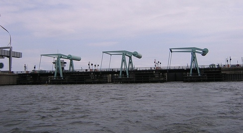
| Function / usage: |
Flood barrier |
|---|
Awards and Distinctions
| 2001 |
for registered users |
|---|
Location
| Location: |
Cardiff, Wales, United Kingdom |
|---|---|
| Coordinates: | 51° 26' 53.16" N 3° 9' 52.92" W |
Technical Information
Dimensions
| height | 7.96 m | |
| length | 1 100 m | |
| spillway capacity | 2 250 m³/s |
Cost
| cost of construction | Pound sterling 120 000 000 |
Participants
Currently there is no information available about persons or companies having participated in this project.
Relevant Web Sites

Relevant Publications
- (2002): Cardiff Bay Barrage. In: Proceedings of the Institution of Civil Engineers - Water and Maritime Engineering, v. 154, n. 2 (June 2002), pp. 81-88.
- (2002): Cardiff Bay Barrage. In: Proceedings of the Institution of Civil Engineers - Maritime Engineering, v. 154, n. 2 (June 2002), pp. 81-88.
- (2002): Cardiff Bay Barrage and Cardiff Bay. In: Proceedings of the Institution of Civil Engineers - Water and Maritime Engineering, v. 154, n. 2 (June 2002), pp. 79-80.
- (2002): Cardiff Bay Barrage and Cardiff Bay. In: Proceedings of the Institution of Civil Engineers - Maritime Engineering, v. 154, n. 2 (June 2002), pp. 79-80.
- (2002): Cardiff Bay Barrage: construction. In: Proceedings of the Institution of Civil Engineers - Water and Maritime Engineering, v. 154, n. 2 (June 2002), pp. 137-148.
- About this
data sheet - Structure-ID
20026292 - Published on:
20/02/2007 - Last updated on:
16/05/2015
Structurae cooperates with


