General Information
| Completion: | 1998 |
|---|---|
| Status: | in use |
Project Type
| Function / usage: |
Pedestrian bridge (footbridge) |
|---|
Location
| Location: |
Bourne End, Buckinghamshire, South East England, England, United Kingdom |
|---|---|
| Crosses: |
|
| Next to: |
Bourne End Railway Bridge (1895)
|
| Coordinates: | 51° 34' 30.10" N 0° 42' 51.34" W |
Technical Information
There currently is no technical data available.
Excerpt from Wikipedia
Bourne End Railway Bridge is a railway bridge carrying the Marlow Branch Line, and a footpath over the River Thames in Bourne End, Buckinghamshire, England. It crosses the Thames on the reach between Cookham Lock and Marlow Lock.
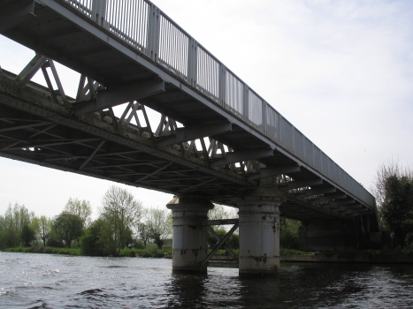
The bridge was originally constructed in wood by Isambard Kingdom Brunel as part of the Wycombe Railway, opened in 1854 and operated in broad gauge until 1870. The narrow spans were unpopular with river traffic and it was reconstructed in steel in 1895. A footbridge, cantilevered out from the railway bridge was added in 1992, to take the Thames Path across the river, which substitutes for the original towpath crossing point at Spade Oak ferry, further upstream.
In 2013, the bridge was restored and repainted in green, and a large number of rivets which had rusted away were replaced. The restoration took nearly a year to complete, being finished in December. The line is due to be electrified by 2019.
Text imported from Wikipedia article "Bourne End Railway Bridge" and modified on July 23, 2019 according to the CC-BY-SA 4.0 International license.
Participants
Currently there is no information available about persons or companies having participated in this project.
Relevant Web Sites
- About this
data sheet - Structure-ID
20011385 - Published on:
04/01/2004 - Last updated on:
02/01/2017


