General Information
Project Type
| Function / usage: |
Temple |
|---|---|
| Material: |
Masonry structure |
Awards and Distinctions
| 1992 |
part of an ensemble
for registered users |
|---|
Location
Technical Information
Materials
| building structure |
sandstone
|
|---|
Excerpt from Wikipedia
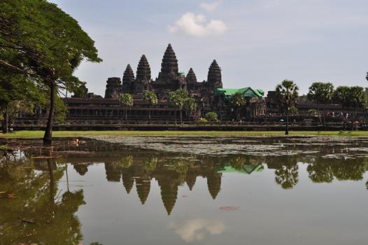
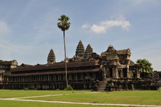
Angkor Wat (/ˌæŋkɔːr ˈwɒt/; Khmer: អង្គរវត្ត, "City/Capital of Temples") is a temple complex in Cambodia and one of the largest religious monuments in the world, on a site measuring 162.6 hectares (1,626,000 m²; 402 acres). Originally constructed as a Hindu temple dedicated to the god Vishnu for the Khmer Empire, it was gradually transformed into a Buddhist temple towards the end of the 12th century. It was built by the Khmer King Suryavarman II in the early 12th century in Yaśodharapura (Khmer: យសោធរបុរៈ, present-day Angkor), the capital of the Khmer Empire, as his state temple and eventual mausoleum. Breaking from the Shaiva tradition of previous kings, Angkor Wat was instead dedicated to Vishnu. As the best-preserved temple at the site, it is the only one to have remained a significant religious centre since its foundation. The temple is at the top of the high classical style of Khmer architecture. It has become a symbol of Cambodia, appearing on its national flag, and it is the country's prime attraction for visitors.
Angkor Wat combines two basic plans of Khmer temple architecture: the temple-mountain and the later galleried temple. It is designed to represent Mount Meru, home of the devas in Hindu mythology: within a moat more than 5 kilometres (3 mi) long and an outer wall 3.6 kilometres (2.2 mi) long are three rectangular galleries, each raised above the next. At the centre of the temple stands a quincunx of towers. Unlike most Angkorian temples, Angkor Wat is oriented to the west; scholars are divided as to the significance of this. The temple is admired for the grandeur and harmony of the architecture, its extensive bas-reliefs, and for the numerous devatas adorning its walls.
Etymology
The modern name, Angkor Wat (Khmer: អង្គរវត្ត) (alternate name: Nokor Wat, Khmer: នគរវត្ត), means "Temple City" or "City of Temples" in Khmer; Angkor (Khmer: អង្គរ) meaning "city" or "capital city", is a vernacular form of the word nokor (Khmer: នគរ), which comes from the Sanskrit word nagara (Devanāgarī: नगर). Wat (Khmer: វត្ត) is the Khmer word for "temple grounds", also derived from Sanskrit vāṭa (Devanāgarī: वाट), meaning "enclosure".
The original name of the temple was Vrah Viṣṇuloka or Parama Viṣṇuloka (Sanskrit), (Khmer: បរមវិស្ណុលោក – Barom Visnulōk) which means the sacred dwelling of Vishnu.
History
Angkor Wat lies 5.5 kilometres (3.4 mi) north of the modern town of Siem Reap, and a short distance south and slightly east of the previous capital, which was centred at Baphuon. In an area of Cambodia where there is an important group of ancient structures, it is the southernmost of Angkor's main sites.
According to legend, the construction of Angkor Wat was ordered by Indra to serve as a palace for his son Precha Ket Mealea. According to the 13th-century Chinese traveller Zhou Daguan, some believed that the temple was constructed in a single night by a divine architect.
The initial design and construction of the temple took place in the first half of the 12th century, during the reign of Suryavarman II (ruled 1113 – c. 1150). Dedicated to Vishnu, it was built as the king's state temple and capital city. As neither the foundation stela nor any contemporary inscriptions referring to the temple have been found, its original name is unknown, but it may have been known as "Varah Vishnu-lok" after the presiding deity. Work seems to have ended shortly after the king's death, leaving some of the bas-relief decoration unfinished. In 1177, approximately 27 years after the death of Suryavarman II, Angkor was sacked by the Chams, the traditional enemies of the Khmer. Thereafter the empire was restored by a new king, Jayavarman VII, who established a new capital and state temple (Angkor Thom and the Bayon respectively) a few kilometres to the north.
Towards the end of the 12th century, Angkor Wat gradually transformed from a Hindu centre of worship to Buddhism, which continues to the present day. Angkor Wat is unusual among the Angkor temples in that although it was largely neglected after the 16th century it was never completely abandoned. Fourteen inscriptions dated from the 17th century discovered in Angkor area testify to Japanese Buddhist pilgrims that had established small settlements alongside Khmer locals. At that time, the temple was thought by the Japanese visitors as the famed Jetavana garden of the Buddha, which originally located in the kingdom of Magadha, India. The best-known inscription tells of Ukondafu Kazufusa, who celebrated the Khmer New Year at Angkor Wat in 1632.
One of the first Western visitors to the temple was António da Madalena, a Portuguese friar who visited in 1586 and said that it "is of such extraordinary construction that it is not possible to describe it with a pen, particularly since it is like no other building in the world. It has towers and decoration and all the refinements which the human genius can conceive of."
In the mid-19th century, the temple was effectively rediscovered by the French naturalist and explorer Henri Mouhot, who popularised the site in the West through the publication of travel notes, in which he wrote:
“One of these temples, a rival to that of Solomon, and erected by some ancient Michelangelo, might take an honorable place beside our most beautiful buildings. It is grander than anything left to us by Greece or Rome, and presents a sad contrast to the state of barbarism in which the nation is now plunged.”
Angkor Wat may relate to the architecture of the Greek and Roman record explored in terms of the west rather than east orientation of the temple. Some architects have written that it is 'correct' for the construction to be facing to the west. In temple orientations for the Greek and Etruscan context, west is associated with "right" and the "underworld" to suggest a religious connection of the building.
Mouhot, like other early Western visitors, found it difficult to believe that the Khmers could have built the temple and mistakenly dated it to around the same era as Rome. His reports inspired the French government, already an established presence in Indochina, to begin a systematic study of the ruins. The true history of Angkor Wat was pieced together from stylistic and epigraphic evidence accumulated during subsequent clearing and restoration work. There were no ordinary dwellings or houses or other signs of settlement, including cooking utensils, weapons, or items of clothing usually found at ancient sites. Instead there is only the evidence of the monuments themselves. An exploration commission began drawing up a list of principal monuments. Subsequent missions copied inscriptions written on Angkor buildings so scholars might translate them and learn something of Angkor's history. By 1885 they had worked up a chronology of the rulers and developed the outlines of a description of the civilization that had produced the temple complex. In 1898 the French decided to commit substantial funds to Angkor's preservation. Centuries of neglect had permitted the jungle to recapture many of the more significant structures, and unless efforts were made to free the buildings from the embrace of huge banyan and silk-cotton trees, they might soon be crushed to destruction.
The 20th century saw considerable restoration of Angkor Wat. Gradually teams of laborers and archeologists pushed back the jungle and exposed the expanses of stone, permitting the sun once again to illuminate the dark corners of the temple. Work was interrupted by the Cambodian Civil War and Khmer Rouge control of the country during the 1970s and 1980s, but relatively little damage was done during this period. Camping Khmer Rouge forces used whatever wood remained in the building structures for firewood, and a shoot-out between Khmer Rouge and Vietnamese forces put a few bullet holes in a bas relief. Far more damage was done after the wars, by art thieves working out of Thailand, which, in the late 1980s and early 1990s, claimed almost every head that could be lopped off the structures, including reconstructions.
The temple is a powerful symbol of Cambodia, and is a source of great national pride that has factored into Cambodia's diplomatic relations with France, the United States and its neighbour Thailand. A depiction of Angkor Wat has been a part of Cambodian national flags since the introduction of the first version circa 1863. From a larger historical and even transcultural perspective, however, the temple of Angkor Wat did not become a symbol of national pride sui generis but had been inscribed into a larger politico-cultural process of French-colonial heritage production in which the original temple site was presented in French colonial and universal exhibitions in Paris and Marseille between 1889 and 1937. Angkor Wat's aesthetics were also on display in the plaster cast museum of Louis Delaporte called musée Indo-chinois which existed in the Parisian Trocadero Palace from c.1880 to the mid-1920s.
The splendid artistic legacy of Angkor Wat and other Khmer monuments in the Angkor region led directly to France adopting Cambodia as a protectorate on 11 August 1863 and invading Siam to take control of the ruins. This quickly led to Cambodia reclaiming lands in the northwestern corner of the country that had been under Siamese (Thai) control since AD 1351 (Manich Jumsai 2001), or by some accounts, AD 1431. Cambodia gained independence from France on 9 November 1953 and has controlled Angkor Wat since that time. It is safe to say that from the colonial period onwards until the site's nomination as UNESCO World Heritage in 1992, this specific temple of Angkor Wat was instrumental in the formation of the modern and gradually globalised concept of built cultural heritage.
In December 2015, it was announced that a research team from University of Sydney had found a previously unseen ensemble of buried towers built and demolished during the construction of Angkor Wat, as well as massive structure of unknown purpose on its south side and wooden fortifications. The findings also include evidence of low-density residential occupation in the region, with a road grid, ponds and mounds. These indicate that the temple precinct, bounded by moat and wall, may not have been used exclusively by the priestly elite, as was previously thought. The team used LiDAR, ground-penetrating radar and targeted excavation to map Angkor Wat.
Architecture
Site and plan
Angkor Wat is a unique combination of the temple mountain (the standard design for the empire's state temples) and the later plan of concentric galleries. The construction of Angkor Wat also suggests that there was a celestial significance with certain features of the temple. This is observed in the temple's east-west orientation, and lines of sight from terraces within the temple that show specific towers to be at the precise location of the sunrise on a solstice. The temple is a representation of Mount Meru, the home of the gods: the central quincunx of towers symbolises the five peaks of the mountain, and the walls and moat symbolize the surrounding mountain ranges and ocean. Access to the upper areas of the temple was progressively more exclusive, with the laity being admitted only to the lowest level.
Unlike most Khmer temples, Angkor Wat is oriented to the west rather than the east. This has led many (including Maurice Glaize and George Coedès) to conclude that Suryavarman intended it to serve as his funerary temple. Further evidence for this view is provided by the bas-reliefs, which proceed in a counter-clockwise direction— prasavya in Hindu terminology—as this is the reverse of the normal order. Rituals take place in reverse order during Brahminic funeral services. The archaeologist Charles Higham also describes a container which may have been a funerary jar which was recovered from the central tower. It has been nominated by some as the greatest expenditure of energy on the disposal of a corpse. Freeman and Jacques, however, note that several other temples of Angkor depart from the typical eastern orientation, and suggest that Angkor Wat's alignment was due to its dedication to Vishnu, who was associated with the west.
A further interpretation of Angkor Wat has been proposed by Eleanor Mannikka. Drawing on the temple's alignment and dimensions, and on the content and arrangement of the bas-reliefs, she argues that the structure represents a claimed new era of peace under King Suryavarman II: "as the measurements of solar and lunar time cycles were built into the sacred space of Angkor Wat, this divine mandate to rule was anchored to consecrated chambers and corridors meant to perpetuate the king's power and to honour and placate the deities manifest in the heavens above." Mannikka's suggestions have been received with a mixture of interest and scepticism in academic circles. She distances herself from the speculations of others, such as Graham Hancock, that Angkor Wat is part of a representation of the constellation Draco.
The Angkor Wat temple's main tower aligns to the morning sun of the Spring Equinox.
Style
Angkor Wat is the prime example of the classical style of Khmer architecture—the Angkor Wat style—to which it has given its name. By the 12th century Khmer architects had become skilled and confident in the use of sandstone (rather than brick or laterite) as the main building material. Most of the visible areas are of sandstone blocks, while laterite was used for the outer wall and for hidden structural parts. The binding agent used to join the blocks is yet to be identified, although natural resins or slaked lime has been suggested.
The temple has drawn praise above all for the harmony of its design. According to Maurice Glaize, a mid-20th-century conservator of Angkor, the temple "attains a classic perfection by the restrained monumentality of its finely balanced elements and the precise arrangement of its proportions. It is a work of power, unity and style."
Architecturally, the elements characteristic of the style include: the ogival, redented towers shaped like lotus buds; half-galleries to broaden passageways; axial galleries connecting enclosures; and the cruciform terraces which appear along the main axis of the temple. Typical decorative elements are devatas (or apsaras), bas-reliefs, and on pediments extensive garlands and narrative scenes. The statuary of Angkor Wat is considered conservative, being more static and less graceful than earlier work. Other elements of the design have been destroyed by looting and the passage of time, including gilded stucco on the towers, gilding on some figures on the bas-reliefs, and wooden ceiling panels and doors.
Features
Outer enclosure
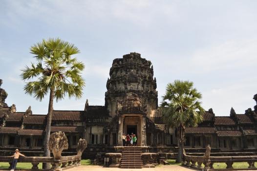
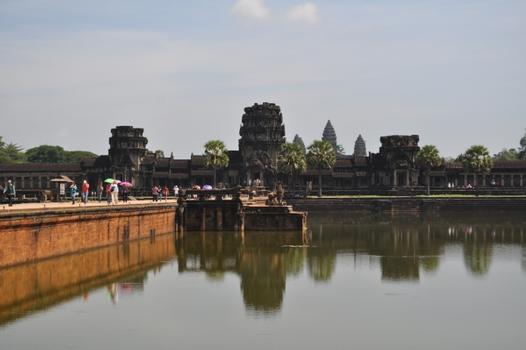
The outer wall, 1,024 m (3,360 ft) by 802 m (2,631 ft) and 4.5 m (15 ft) high, is surrounded by a 30 m (98 ft) apron of open ground and a moat 190 m (620 ft) wide and over 5 kilometres (3 mi) in perimeter. Access to the temple is by an earth bank to the east and a sandstone causeway to the west; the latter, the main entrance, is a later addition, possibly replacing a wooden bridge. There are gopuras at each of the cardinal points; the western is by far the largest and has three ruined towers. Glaize notes that this gopura both hides and echoes the form of the temple proper. Under the southern tower is a statue of Vishnu, known as Ta Reach, which may originally have occupied the temple's central shrine. Galleries run between the towers and as far as two further entrances on either side of the gopura often referred to as "elephant gates", as they are large enough to admit those animals. These galleries have square pillars on the outer (west) side and a closed wall on the inner (east) side. The ceiling between the pillars is decorated with lotus rosettes; the west face of the wall with dancing figures; and the east face of the wall with balustered windows, dancing male figures on prancing animals, and devatas, including (south of the entrance) the only one in the temple to be showing her teeth.
The outer wall encloses a space of 820,000 square metres (203 acres), which besides the temple proper was originally occupied by the city and, to the north of the temple, the royal palace. Like all secular buildings of Angkor, these were built of perishable materials rather than of stone, so nothing remains of them except the outlines of some of the streets. Most of the area is now covered by forest. A 350 m (1,150 ft) causeway connects the western gopura to the temple proper, with naga balustrades and six sets of steps leading down to the city on either side. Each side also features a library with entrances at each cardinal point, in front of the third set of stairs from the entrance, and a pond between the library and the temple itself. The ponds are later additions to the design, as is the cruciform terrace guarded by lions connecting the causeway to the central structure.
Central structure
The middle tower of Angkor Wat symbolizes the sacred mountain, mount Meru. Aerial view of the central structure; in front of the central structure lies the cruciform terrace.
The temple stands on a terrace raised higher than the city. It is made of three rectangular galleries rising to a central tower, each level higher than the last. Mannikka interprets these galleries as being dedicated to the king, Brahma, the moon, and Vishnu. Each gallery has a gopura at each of the points, and the two inner galleries each have towers at their corners, forming a quincunx with the central tower. Because the temple faces west, the features are all set back towards the east, leaving more space to be filled in each enclosure and gallery on the west side; for the same reason the west-facing steps are shallower than those on the other sides.
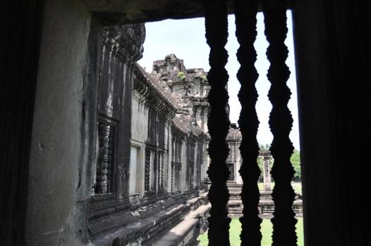
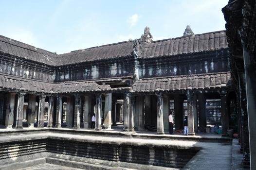
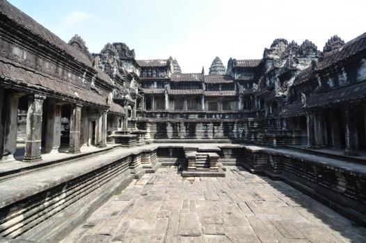
The outer gallery measures 187 m (614 ft) by 215 m (705 ft), with pavilions rather than towers at the corners. The gallery is open to the outside of the temple, with columned half-galleries extending and buttressing the structure. Connecting the outer gallery to the second enclosure on the west side is a cruciform cloister called Preah Poan (the "Hall of a Thousand Gods"). Buddha images were left in the cloister by pilgrims over the centuries, although most have now been removed. This area has many inscriptions relating the good deeds of pilgrims, most written in Khmer but others in Burmese and Japanese. The four small courtyards marked out by the cloister may originally have been filled with water. North and south of the cloister are libraries.
Beyond, the second and inner galleries are connected to each other and to two flanking libraries by another cruciform terrace, again a later addition. From the second level upwards, devatas abound on the walls, singly or in groups of up to four. The second-level enclosure is 100 m (330 ft) by 115 m (377 ft), and may originally have been flooded to represent the ocean around Mount Meru. Three sets of steps on each side lead up to the corner towers and gopuras of the inner gallery. The very steep stairways represent the difficulty of ascending to the kingdom of the gods. This inner gallery, called the Bakan, is a 60 m (200 ft) square with axial galleries connecting each gopura with the central shrine, and subsidiary shrines located below the corner towers. The roofings of the galleries are decorated with the motif of the body of a snake ending in the heads of lions or garudas. Carved lintels and pediments decorate the entrances to the galleries and to the shrines. The tower above the central shrine rises 43 m (141 ft) to a height of 65 m (213 ft) above the ground; unlike those of previous temple mountains, the central tower is raised above the surrounding four. The shrine itself, originally occupied by a statue of Vishnu and open on each side, was walled in when the temple was converted to Theravada Buddhism, the new walls featuring standing Buddhas. In 1934, the conservator George Trouvé excavated the pit beneath the central shrine: filled with sand and water it had already been robbed of its treasure, but he did find a sacred foundation deposit of gold leaf two metres above ground level.
Decoration
The bas-relief of the Churning of the Sea of Milk shows Vishnu in the centre, his turtle Avatar Kurma below, asuras and devas to left and right, and apsaras and Indra above. Devatas are characteristic of the Angkor Wat style.
Integrated with the architecture of the building, and one of the causes for its fame is Angkor Wat's extensive decoration, which predominantly takes the form of bas-relief friezes. The inner walls of the outer gallery bear a series of large-scale scenes mainly depicting episodes from the Hindu epics the Ramayana and the Mahabharata. Higham has called these, "the greatest known linear arrangement of stone carving". From the north-west corner anti-clockwise, the western gallery shows the Battle of Lanka (from the Ramayana, in which Rama defeats Ravana) and the Battle of Kurukshetra (from the Mahabharata, showing the mutual annihilation of the Kaurava and Pandava clans). On the southern gallery follow the only historical scene, a procession of Suryavarman II, then the 32 hells and 37 heavens of Hinduism.
On the eastern gallery is one of the most celebrated scenes, the Churning of the Sea of Milk, showing 92 asuras and 88 devas using the serpent Vasuki to churn the sea under Vishnu's direction (Mannikka counts only 91 asuras, and explains the asymmetrical numbers as representing the number of days from the winter solstice to the spring equinox, and from the equinox to the summer solstice). It is followed by Vishnu defeating asuras (a 16th-century addition). The northern gallery shows Krishna's victory over Bana (where according to Glaize, "The workmanship is at its worst").
Angkor Wat is decorated with depictions of apsaras and devata; there are more than 1,796 depictions of devata in the present research inventory. Angkor Wat architects employed small apsara images (30 cm (12 in)–40 cm (16 in)) as decorative motifs on pillars and walls. They incorporated larger devata images (all full-body portraits measuring approximately 95 cm (37 in)–110 cm (43 in)) more prominently at every level of the temple from the entry pavilion to the tops of the high towers. In 1927, Sappho Marchal published a study cataloging the remarkable diversity of their hair, headdresses, garments, stance, jewellery and decorative flowers, which Marchal concluded were based on actual practices of the Angkor period.
Construction techniques
The stones, as smooth as polished marble, were laid without mortar with very tight joints that are sometimes hard to find. The blocks were held together by mortise and tenon joints in some cases, while in others they used dovetails and gravity. The blocks were presumably put in place by a combination of elephants, coir ropes, pulleys and bamboo scaffolding. Henri Mouhot noted that most of the blocks had holes 2.5 cm (0.98 in) in diameter and 3 cm (1.2 in) deep, with more holes on the larger blocks. Some scholars have suggested that these were used to join them together with iron rods, but others claim they were used to hold temporary pegs to help manoeuvre them into place.
The monument was made out of 5 million to 10 million sandstone blocks with a maximum weight of 1.5 tons each. In fact, the entire city of Angkor used up far greater amounts of stone than all the Egyptian pyramids combined, and occupied an area significantly greater than modern-day Paris. Moreover, unlike the Egyptian pyramids which use limestone quarried barely 0.5 km (0.31 mi) away all the time, the entire city of Angkor was built with sandstone quarried 40 km (25 mi) (or more) away. This sandstone had to be transported from Mount Kulen, a quarry approximately 25 miles (40 km) to the northeast. The route has been suggested to span 35 kilometres (22 mi) along a canal towards Tonlé Sap lake, another 35 kilometres (22 mi) crossing the lake, and finally 15 kilometres (9.3 mi) against the current along Siem Reap River, making a total journey of 90 kilometres (56 mi). However, Etsuo Uchida and Ichita Shimoda of Waseda University in Tokyo, Japan have discovered in 2011 a shorter 35-kilometre (22 mi) canal connecting Mount Kulen and Angkor Wat using satellite imagery. The two believe that the Khmer used this route instead.
Virtually all of its surfaces, columns, lintels and even roofs are carved. There are miles of reliefs illustrating scenes from Indian literature including unicorns, griffins, winged dragons pulling chariots as well as warriors following an elephant-mounted leader and celestial dancing girls with elaborate hairstyles. The gallery wall alone is decorated with almost 1,000 square metres of bas reliefs. Holes on some of the Angkor walls indicate that they may have been decorated with bronze sheets. These were highly prized in ancient times and were a prime target for robbers. While excavating Khajuraho, Alex Evans, a stonemason and sculptor, recreated a stone sculpture under 4 feet (1.2 m), this took about 60 days to carve. Roger Hopkins and Mark Lehner also conducted experiments to quarry limestone which took 12 quarrymen 22 days to quarry about 400 tons of stone. The labour force to quarry, transport, carve and install so much sandstone must have run into the thousands including many highly skilled artisans. The skills required to carve these sculptures were developed hundreds of years earlier, as demonstrated by some artefacts that have been dated to the seventh century, before the Khmer came to power.
Angkor Wat today
Restoration and conservation
As with most other ancient temples in Cambodia, Angkor Wat has faced extensive damage and deterioration by a combination of plant overgrowth, fungi, ground movements, war damage and theft. The war damage to Angkor Wat's temples however has been very limited, compared to the rest of Cambodia's temple ruins, and it has also received the most attentive restoration.
The restoration of Angkor Wat in the modern era began with the establishment of the Conservation d'Angkor (Angkor Conservancy) by the École française d'Extrême-Orient (EFEO) in 1908; before that date, activities at the site were primarily concerned with exploration. The Conservation d'Angkor was responsible for the research, conservation, and restoration activities carried out at Angkor until the early 1970s, and a major restoration of Angkor was undertaken in the 1960s. However, work on Angkor was abandoned during the Khmer Rouge era and the Conservation d'Angkor was disbanded in 1975. Between 1986 and 1992, the Archaeological Survey of India carried out restoration work on the temple, as France did not recognise the Cambodian government at the time. Criticism has been raised about both the early French restoration attempts and particularly the later Indian work, with concerns over damage done to the stone surface by the use of chemicals and cement.
The restored head of a naga beside an unrestored lion at the start of the causeway leading to the entrance of Angkor Wat. The contrast of restored and unrestored figures is deliberate. The major restoration of the causeway was first initiated in the 1960s by the French.
In 1992, following an appeal for help by Norodom Sihanouk, Angkor Wat was listed in UNESCO's World Heritage in Danger (later removed in 2004) and World Heritage Site together with an appeal by UNESCO to the international community to save Angkor. Zoning of the area was set up to protect the Angkor site in 1994, APSARA was established in 1995 to protect and manage the area, and a law to protect Cambodian heritage was passed in 1996. A number of countries such as France, Japan and China are currently involved in various Angkor Wat conservation projects. The German Apsara Conservation Project (GACP) is working to protect the devatas, and other bas-reliefs which decorate the temple, from damage. The organisation's survey found that around 20% of the devatas were in very poor condition, mainly because of natural erosion and deterioration of the stone but in part also due to earlier restoration efforts. Other work involves the repair of collapsed sections of the structure, and prevention of further collapse: the west facade of the upper level, for example, has been buttressed by scaffolding since 2002, while a Japanese team completed restoration of the north library of the outer enclosure in 2005. World Monuments Fund began conservation work on the Churning of the Sea of Milk Gallery in 2008 after several years of studies on its condition. The project restored the traditional Khmer roofing system and removed cement used in earlier restoration attempts that had resulted in salts entering the structure behind the bas-relief, discoloring and damaging the sculpted surfaces. The main phase of work ended in 2012, with the final component being the installation of finials on the roof of the gallery in 2013.
Microbial biofilms have been found degrading sandstone at Angkor Wat, Preah Khan, and the Bayon and West Prasat in Angkor. The dehydration- and radiation-resistant filamentous cyanobacteria can produce organic acids that degrade the stone. A dark filamentous fungus was found in internal and external Preah Khan samples, while the alga Trentepohlia was found only in samples taken from external, pink-stained stone at Preah Khan. Replicas were also made to replace some of the lost or damaged sculptures.
Tourism
Since the 1990s, Angkor Wat has become a major tourist destination. In 1993, there were only 7,650 visitors to the site; by 2004, government figures show that 561,000 foreign visitors had arrived in Siem Reap province that year, approximately 50% of all foreign tourists in Cambodia. The number reached over a million in 2007, and over two million by 2012. Most visited Angkor Wat, which received over two million foreign tourists in 2013. The site was managed by the private SOKIMEX group between 1990 and 2016, which rented it from the Cambodian government. The influx of tourists has so far caused relatively little damage, other than some graffiti; ropes and wooden steps have been introduced to protect the bas-reliefs and floors, respectively. Tourism has also provided some additional funds for maintenance—as of 2000 approximately 28% of ticket revenues across the whole Angkor site was spent on the temples—although most work is carried out by teams sponsored by foreign governments rather than by the Cambodian authorities.
Since Angkor Wat has seen significant growth in tourism throughout the years, UNESCO and its International Co-ordinating Committee for the Safeguarding and Development of the Historic Site of Angkor (ICC), in association with representatives from the Royal Government and APSARA, organised seminars to discuss the concept of "cultural tourism". Wanting to avoid commercial and mass tourism, the seminars emphasised the importance of providing high quality accommodation and services in order for the Cambodian government to benefit economically, while also incorporating the richness of Cambodian culture. In 2001, this incentive resulted in the concept of the "Angkor Tourist City" which would be developed with regard to traditional Khmer architecture, contain leisure and tourist facilities, and provide luxurious hotels capable of accommodating large numbers of tourists.
The prospect of developing such large tourist accommodations has encountered concerns from both APSARA and the ICC, claiming that previous tourism developments in the area have neglected construction regulations and more of these projects have the potential to damage landscape features. Also, the large scale of these projects have begun to threaten the quality of the nearby town's water, sewage, and electricity systems. It has been noted that such high frequency of tourism and growing demand for quality accommodations in the area, such as the development of a large highway, has had a direct effect on the underground water table, subsequently straining the structural stability of the temples at Angkor Wat. Locals of Siem Reap have also voiced concern that the charm and atmosphere of their town have been compromised in order to entertain tourism. Since this local atmosphere is the key component to projects like Angkor Tourist City, the local officials continue to discuss how to successfully incorporate future tourism without sacrificing local values and culture.
At the ASEAN Tourism Forum 2012, it was agreed that Borobudur and Angkor Wat would become sister sites and the provinces sister provinces.
Text imported from Wikipedia article "Angkor Wat" and modified on July 22, 2019 according to the CC-BY-SA 4.0 International license.
Participants
Currently there is no information available about persons or companies having participated in this project.
Relevant Web Sites
Relevant Publications
- (2005): Prinzipielle Beobachtungen zu Bauweise und Verfall der Gewölbe in den Tempeln von Angkor in Kambodscha. In: Mauerwerk, v. 9, n. 1 (February 2005), pp. 14-20.
- (2005): Qu'est-ce que l'architecture?. Une histoire de l'Architecture. Editions Gründ, Paris (France), pp. 250-251.
- (2001): Structural Damage and Remedial Measures for the Temples of Angkor, Cambodia. In: Structural Engineering International, v. 11, n. 4 (November 2001), pp. 234-236.
- About this
data sheet - Structure-ID
10000778 - Published on:
25/08/2005 - Last updated on:
28/05/2021


