
General Information
Project Type
| Structure: |
Gravity dam |
|---|---|
| Function / usage: |
Hydroelectric dam / plant |
| Material: |
Concrete dam |
Location
Technical Information
Dimensions
| height | 78.00 m | |
| length | 6 900 m | |
| reservoir capacity | 45.5 km³ | |
| spillway capacity | 110 000 m³/s |
Materials
| dam structure |
reinforced concrete
|
|---|
Excerpt from Wikipedia
The Tucuruí Dam (Tucuruí means "grasshopper's water", translated from Tupí language; Portuguese:Tucuruí) is a concrete gravity dam on the Tocantins River located on the Tucuruí County in the State of Pará, Brazil. The main purpose of the dam is hydroelectric power production and navigation. It is the first large-scale hydroelectric project in the Brazilian Amazon rainforest. The installed capacity of the 25-unit plant is 8,370 megawatts (11,220,000 hp). Phase I construction began in 1980 and ended in 1984 while Phase II began in 1998 and ended in 2010. The dam was featured in the 1985 film The Emerald Forest.
Background and history
The initial reconnaissance of the Tocantins River was carried out by the U.S. Bureau of Reclamation and USAID in 1964. The Amazon Energy Studies Coordination Committee was formed in 1968 and begin hydroelectric project studies in 1969. Before the committee closed, Eletrobrás commissioned further studies, called the "Tocantins Studies", on the entire Tocantins River Basin. In 1973, Brazilian President Emílio Médici was asked to assign funding for a dam on the Tocantins. Two options were available: the Tucuruí Dam and Santo Antonio Dam (unrelated to the current Santo Antonio Dam project on the Madeira river). In 1973, the Engevix-Ecotec consortium carried out feasibility studies and the Santo Antonio Dam was ruled out in 1974. Later in 1974, the Tucuruí Dam was approved during the President Ernesto Geisel administration.
The dam was built primarily as a source of hydroelectricity and second for navigation between the upper and lower Tocantins River. The electricity was and is primarily supplied to industrial interests from the aluminum industry like Brazil's Companhia Vale do Rio Doce. Communities in Northeast Brazil would also benefit as well, such as Belém, São Luiz, Marabá, and later Eastern Amazonia. The World Bank refused to fund the dam and most of the funding was procured by Eletronorte and Brazilian institutions such as Eletrobrás, BNH, Banco do Brasil, Caixa Econômica Federal and FINAME. A smaller portion of funding came from Canadian, European and American institutions. In 1975, the consortium formed by the Brazilian companies Engevix and Themag were hired to draw up the basic and executive designs. In 1976, Camargo Correa won the bid to construct the dam.
Construction
Phase I
Construction on Phase I began on November 24, 1975. Phase I called for the construction of the main dam, its dikes, the power house, spillway and upper portion of the navigation locks. On February 1, 1977, concrete-pouring began on site and in September 1978, the river diversion began. On September 6, 1984 the reservoir began filling and 206-days later it was at normal pool. Construction was completed 3 years behind schedule on November 10, 1984. The navigation lock that is part of the dam's design was only partially completed during Phase I with only the upper portion. The construction costs were predicted to be $3.6 billion but rose to over 5.5 billion by construction's end. Including interest during construction, the total cost for Phase I was $7.5 billion. Until 1999, Phase I produced an average of 21,428 terawatt-hours (77,140 PJ) of electricity.
Phase II
Construction on the $1.35 billion Phase II began in June 1998. This phase called for the construction of the new power house for 11 x 375 MW (503,000 hp) Francis turbines and the completion of the navigation lock-system. The new power house is located to the left of the old one and the locks are on the north side of the dam's abutments. Phase II was expected to be completed in 2006 but is behind schedule. The second power house was completed in April 2007 but construction on the navigation locks is behind schedule.
Dam
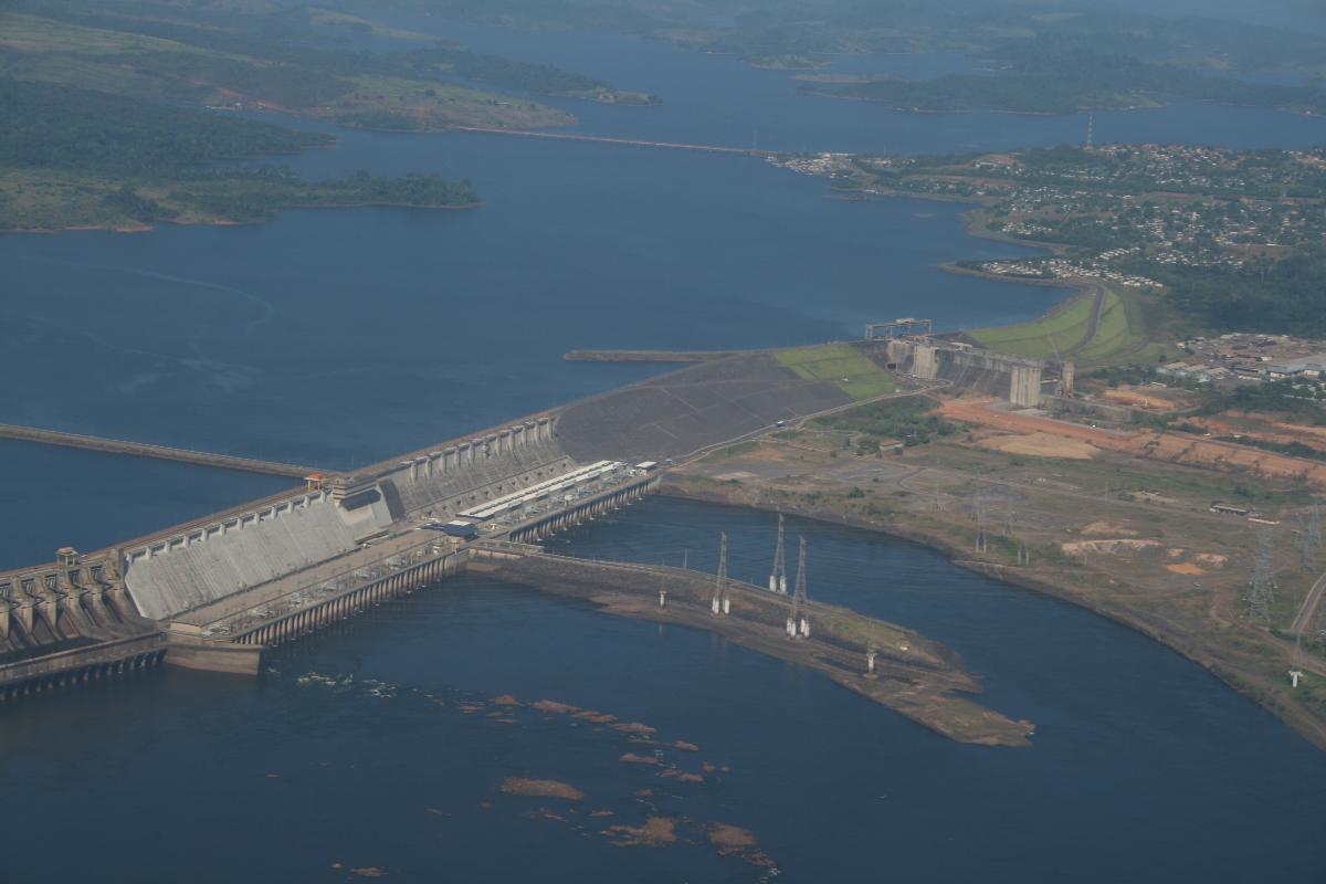
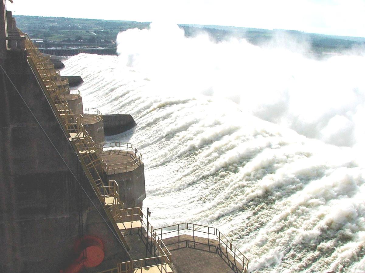
The main portion Tucuruí Dam is a 78-metre-high (256 ft) and 6.9-kilometre-long (4.3 mi) concrete-gravity dam. The addition of the Mojú and Caraipé earth-fill dikes increases the total length to 12,515 metres (41,060 ft). The main dam's Creager-type service spillway is the second largest in the world with a maximum capacity of 110,000 cubic metres per second (3,900,000 cu ft/s). It is controlled by 20 floodgates measuring 20 by 21 metres (66 ft × 69 ft).
Reservoir
The reservoir impounded by the dam has a capacity of 45 cubic kilometres (36,000,000 acre⋅ft) with a live volume of 32 cubic kilometres (26,000,000 acre⋅ft).
Power houses
The 405 by 58 metres (1,329 ft × 190 ft) Phase I power house is concrete and is fitted with an intake and penstocks. Phase I's power house contains 12 x 350 MW (470,000 hp) Francis turbine generators. An auxiliary water intake and auxiliary powerhouse also houses 2 x 22.5 MW (30,200 hp) generators.
Locks
The dam is designed to support two 210 by 33 metres (689 ft × 108 ft) wide navigation locks.
Impact
The Tucuruí Dam brought power to 13 million people and 60% of the power is transferred to industries which create just under 2,000 jobs. Between 25,000 and 35,000 people were removed from the future reservoir zone in the early 1980s. 14,000 people were relocated by the government. 3,750 of these people moved to new islands created by the reservoir which lack adequate infrastructure. Construction of the dam attracted migrants which, along with the reservoir, significantly increased malaria and AIDS cases. The completion of Phase I in 1984 led to a large amount of unemployment among its 20,000 employees and subsequent migration from the area. The flooded area is in the Tocantins-Araguaia-Maranhão moist forests ecoregion, the most degraded in the Amazon region. The overall large influx of people to the area has led to deforestation and negative impacts from increased cattle-raising. The increases of population have also strained existing infrastructure or lack thereof.
Text imported from Wikipedia article "Tucuruí Dam" and modified on August 16, 2020 according to the CC-BY-SA 4.0 International license.
Participants
Currently there is no information available about persons or companies having participated in this project.
Relevant Web Sites

- About this
data sheet - Structure-ID
20003612 - Published on:
17/06/2002 - Last updated on:
14/04/2023


