
General Information
Project Type
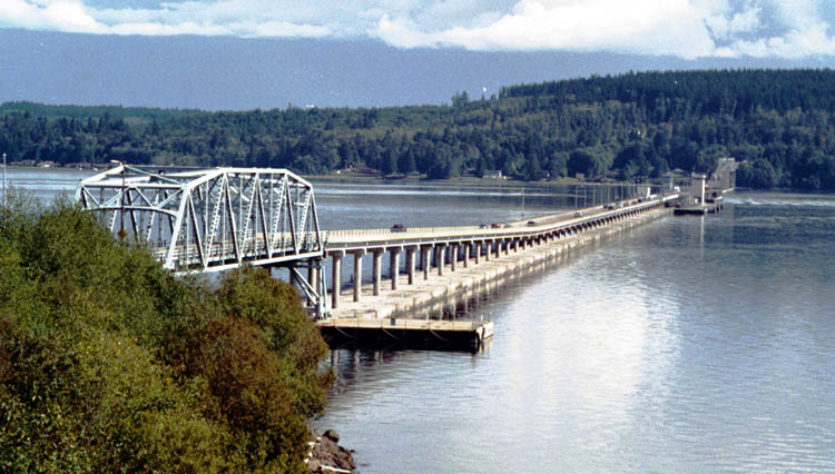
| Structure: |
Pontoon bridge |
|---|---|
| Function / usage: |
Road bridge |
| Material: |
Concrete bridge |
| Structure: |
Retractable bridge Through truss bridge |
Location
| Location: |
Jefferson County, Washington, USA Kitsap County, Washington, USA |
|---|---|
| Address: | WA 104 |
| Location description: |
Connects the north end of Kitsap peninsula to the Olympic peninsula |
| Coordinates: | 47° 51' 36.27" N 122° 37' 30.25" W |
Technical Information
Dimensions
| total length | 2 398.5 m |
Cost
| cost of construction | United States dollar 26 630 000 |
Chronology
| 13 February 1979 | The west half of the bridge failed and sank on February 13, 1979 during a storm carrying wind gusts of 120 miles per hour and sustained winds of 85 miles per hour. |
|---|---|
| October 1982 | Reconstruction of the west half is completed and the bridge is opened to traffic. |
| 29 August 1985 | Tolls are removed. |
Notes
The Hood Canal Bridge was named in honor of William A. Bugge by the Washington Highway Commission at the request of the Washington State Senate on July 12, 1977. William A. Bugge was director of the Department of Highways from 1949 to 1963, and was a leader in the planning and construction of the bridge.
Participants
Relevant Web Sites
-
HistoryLink.org online encyclopedia of Washington State History: Bridge construction project unearths Tse-whit-zen, a largely intact Klallam Indian village, in a major archeological discovery on August 16, 2003.

-
HistoryLink.org online encyclopedia of Washington State History: Hood Canal Bridge opens on August 12, 1961.
-
HistoryLink.org online encyclopedia of Washington State History: Hood Canal Bridge sinks during a severe storm on Tuesday, February 13, 1979.
-
HistoryLink.org online encyclopedia of Washington State History: WSDOT abandons Hood Canal bridge graving dock project located on site of Klallam Indian village and cemetery on December 21, 2004.
-
Wikipedia: Hood Canal Bridge
Relevant Publications
- (1985): Floating Bridge for 100 Year Storm. In: Civil Engineering Magazine, v. 55, n. 6 (June 1985).
- Hood Canal Bridge refit moves steadily ahead. In: Bridge Update, n. 76 (June 2008), pp. 2.
- : Spanning Washington. Historic Highway Bridges of the Evergreen State. Washington State University Press, Pullman (USA), pp. 179-183.
- About this
data sheet - Structure-ID
20010568 - Published on:
01/11/2003 - Last updated on:
28/05/2021
Structurae cooperates with


