
General Information
| Completion: | 1971 |
|---|---|
| Status: | in use |
Project Type
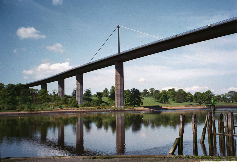
| Structure: |
Three-span cable-stayed bridge |
|---|---|
| Function / usage: |
Motorway bridge / freeway bridge |
| Material: |
Steel bridge Structurae Plus/Pro - Subscribe Now! |
Location
| Location: |
Old Kilpatrick, West Dunbartonshire, Scotland, United Kingdom Erskine, Renfrewshire, Scotland, United Kingdom |
|---|---|
| Address: | A 898 |
| Crosses: |
|
| Coordinates: | 55° 55' 12.36" N 4° 27' 45.31" W |
Technical Information
Dimensions
| main span | 305 m | |
| total length | 1 321.87 m | |
| clearance | 45 m | |
| span lengths of main bridge | 110.00 m - 305.00 m - 110.00 m | |
| deck | deck width | 31.25 m |
| pylon | pylon height | 38.00 m |
Materials
| deck |
steel
|
|---|---|
| pylons |
steel
|
Chronology
| 2 July 1971 | Opening. |
|---|---|
| 4 August 1996 | The bridge is damaged when an oil rig being towed down the River Clyde collides with the deck. |
| 22 August 1996 | The bridge re-opens to cyclists and pedestrians. |
| 30 August 1996 | Cars and motorcycles are allowed to use the bridge again. |
| 22 December 1996 | The bridge is re-opened for heavy goods vehicles as well. The cost of the repairs is GBP 3.6 million with a further GBP 700,000 in lost revenue from tolls. |
| 31 March 2006 | Tolls on the bridge are abolished. |
Participants
Operator
Initial construction
Structural engineering
Contractor
- Christiani & Nielsen
- Fairfield-Mabey
- Lehane Mackenzie (foundations)
- Shand Ltd (foundations)
Stay cable steel supplier

Installation of new access system
Wind tunnel testing

Relevant Web Sites

Relevant Publications
- (1984): Analyses of wind and response data from the Wye and Erskine bridges and comparison with theory. In: Journal of Wind Engineering and Industrial Aerodynamics, v. 17, n. 1 (May 1984), pp. 31-49.
- (1972): Die Erskine-Brücke - eine 1321 m lange Schrägseilbrücke in Schottland. In: Stahlbau, v. 41, n. 1 (January 1972), pp. 26-29.
- (1990): Les grands ponts du monde: Ponts remarquables d'Europe. Brissaud, Poitiers (France), pp. 279.
- (2002): The Refurbishment of Erskine Bridge, Scotland. Presented at: IABSE Symposium: Towards a Better Built Environment - Innovation, Sustainability, Information Technology, Melbourne, Australia, 11-13 September 2002, pp. 1-9.
- (1986): Schrägseilbrücken. Wilhelm Ernst & Sohn Verlag für Architektur und technische Wissenschaften GmbH, Berlin (Germany), pp. 31.
- About this
data sheet - Structure-ID
20000587 - Published on:
14/01/2000 - Last updated on:
05/02/2016
Structurae cooperates with


