
General Information
Project Type
| Structure: |
Tied-arch bridge |
|---|---|
| Function / usage: |
Road bridge |
| Material: |
Reinforced concrete bridge |
Location
| Location: |
Balclutha, Otago, New Zealand |
|---|---|
| Address: | SH1 |
| Location description: |
Over Clutha River |
| Coordinates: | 46° 14' 9.24" S 169° 44' 42" E |
Technical Information
Dimensions
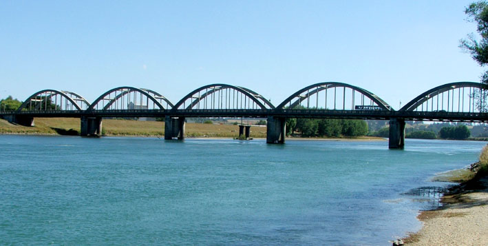
| width | 11.8 m | |
| total length | 244.1 m | |
| span lengths | 6 x 36.6 m | |
| number of spans | 6 |
Materials
| arches |
reinforced concrete
|
|---|
Excerpt from Wikipedia
The Balclutha Road Bridge, which spans the Clutha River in Balclutha, South Otago, New Zealand, is one of the best-known road bridges in New Zealand's South Island. The bridge is often simply known as "The Clutha Bridge", despite the fact that there are numerous bridges across the country's second longest river.
Built between 1933 and 1935, this bowstring bridge was designed by W. L. Newnham to be earthquake and flood resistant, thereby safeguarding it against the two most common natural disasters to occur in southern New Zealand.
The bridge is built from reinforced concrete, with six parabolic curved spans, each of 36.6 metres in length, and a total bridge length of 244.1 metres. A carriageway of 6.7 metres width is flanked on either side by a footpath of 1.4 metres; its total width is 11.8 metres. The bridge carries the South Island's principal highway, State Highway 1 on its route between Dunedin and Invercargill.
The bridge is the third road bridge to stand at or close to this spot. The first, constructed in 1868, was destroyed in massive floods ten years later when a bridge situated upstream at Beaumont was swept downriver and collided with it. A second bridge was constructed in 1881, but was unsuitable for the needs of motorised transport and was eventually replaced by the current structure.
On 13 December 1990 the Balclutha Road Bridge was classified as a Category I Historic Place by the New Zealand Historic Places Trust.
Another bridge, the Balclutha Rail Bridge, stands several hundred metres downstream.
Text imported from Wikipedia article "Balclutha Road Bridge" and modified on 23 July 2019 under the CC-BY-SA 3.0 license.
Participants
Design
- W. Newnham (designer)
Relevant Web Sites

Relevant Publications
- (2001): Bridging the Gap. Early Bridges in New Zealand 1830-1939. Reed Books, Auckland (New Zealand), pp. 155.
- About this
data sheet - Structure-ID
20052135 - Published on:
16/01/2010 - Last updated on:
05/02/2016
Structurae cooperates with


