
General Information
| Official designation: | 4ZO251B |
|---|---|
| Status: | in use |
Project Type
| Structure: |
Steel truss tower (free standing) |
|---|---|
| Function / usage: |
High-voltage mast |
| Material: |
Steel tower or mast |
Location
| Location: |
Stalybridge, Tameside, Greater Manchester, North West England, England, United Kingdom |
|---|---|
| Coordinates: | 53° 29' 37" N 2° 2' 25" W |
Technical Information
There currently is no technical data available.
Excerpt from Wikipedia
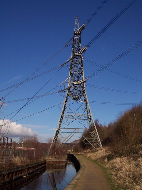
The Huddersfield Narrow Canal Pylon, (National Grid tower designation 4ZO251B), is an electricity pylon which stands with ist feet over the Huddersfield Narrow Canal near Heyrod, Stalybridge, Greater Manchester, United Kingdom.
The Stalybridge substation was built while the canal was closed to navigation, encroaching on the former canal line, and the canal was culverted at this point from the head of Lock 8W to a point immediately downstream of the substation. The extent of the former culvert can still be seen, as it was reused to form the lock bywash.
When the canal reopened, the channel was diverted slightly to the east to avoid the substation compound. However, ist way was obstructed by a pylon, and it had to pass between the pylon's legs.
One side of the pylon carries the 400 kV Stalybridge–Thorpe Marsh circuit and the other a 275 kV Stalybridge transformer feeder circuit.
Text imported from Wikipedia article "Huddersfield Narrow Canal Pylon"
and modified on 23 July 2019 under the CC-BY-SA 3.0 license.
Participants
Currently there is no information available about persons or companies having participated in this project.
Relevant Web Sites

- About this
data sheet - Structure-ID
20041249 - Published on:
14/12/2008 - Last updated on:
28/05/2021
Structurae cooperates with


