
General Information
| Other name(s): | Barrage de Malpasset |
|---|---|
| Completion: | 1954 |
| Status: | collapsed (1959) |
Project Type
| Structure: |
Double-curvature arch dam |
|---|---|
| Function / usage: |
Fresh water dam |
| Material: |
Concrete dam |
Location
| Location: |
Malpasset, Fréjus, Var (83), Provence-Alpes-Côte d'Azur, France |
|---|---|
| Coordinates: | 43° 30' 44" N 6° 45' 25" E |
Technical Information
Dimensions
| height | 60 m | |
| retained water volume | 50 000 000 m³ | |
| crest length | 225 m | |
| crest thickness | 1.5 m | |
| base thickness | 6.82 m | |
| spillway | width | 30 m |
Materials
| dam structure |
reinforced concrete
|
|---|
Chronology
| 2 December 1959, 21:30 | The Malpasset Dam collapses completely. The tidal wave of 50 m hits the town of Fréjus and kills over 400 people. |
|---|
Notes
The dam was never rebuilt.
Excerpt from Wikipedia
The Malpasset Dam (French:Barrage de Malpasset) was an arch dam on the Reyran River, located approximately 7 km north of Fréjus on the French Riviera (Côte d'Azur), Southern France, in the Var department. It collapsed on 2 December 1959, killing 423 people in the resulting flood. The damage amounted to an equivalent total of US$68 million. The event also ushered in the practise of posthumous marriage in France for civilians as many women who lost their fiances were granted the right to marry them after death.
Construction
The dam was a doubly curved equal angle arch type with variable radius. It was built to supply drinking and irrigation water for the region. Construction began in April 1952 and was finished in 1954. Another source reports that construction began as early as 1941. Delays due to lack of funding and labor strikes interrupted construction a few times. The project was led by well-known French engineer André Coyne. Construction cost 580 million francs (by 1955 prices), and was funded and owned by Var département. Concurrent with the dam construction, the A8 autoroute was also being built 1,400 meters further down the course of the Reyran from the dam location.
The dam was supposed to regulate the rate of the flow of the river that it was near and store 50 million cubic meters of water for agriculture, and domestic use and for the tourism sector of the area. The dam was 222 metres in width, 66 metres high, and had a thickness of 6.78 metres at the base and 1.5 metres at the rim.
Disaster
During November 1959, there were the first warning signs: a "trickle of clear water observed high on the right [side]" and then cracks noticed later in the month in the concrete apron at the dam toe.
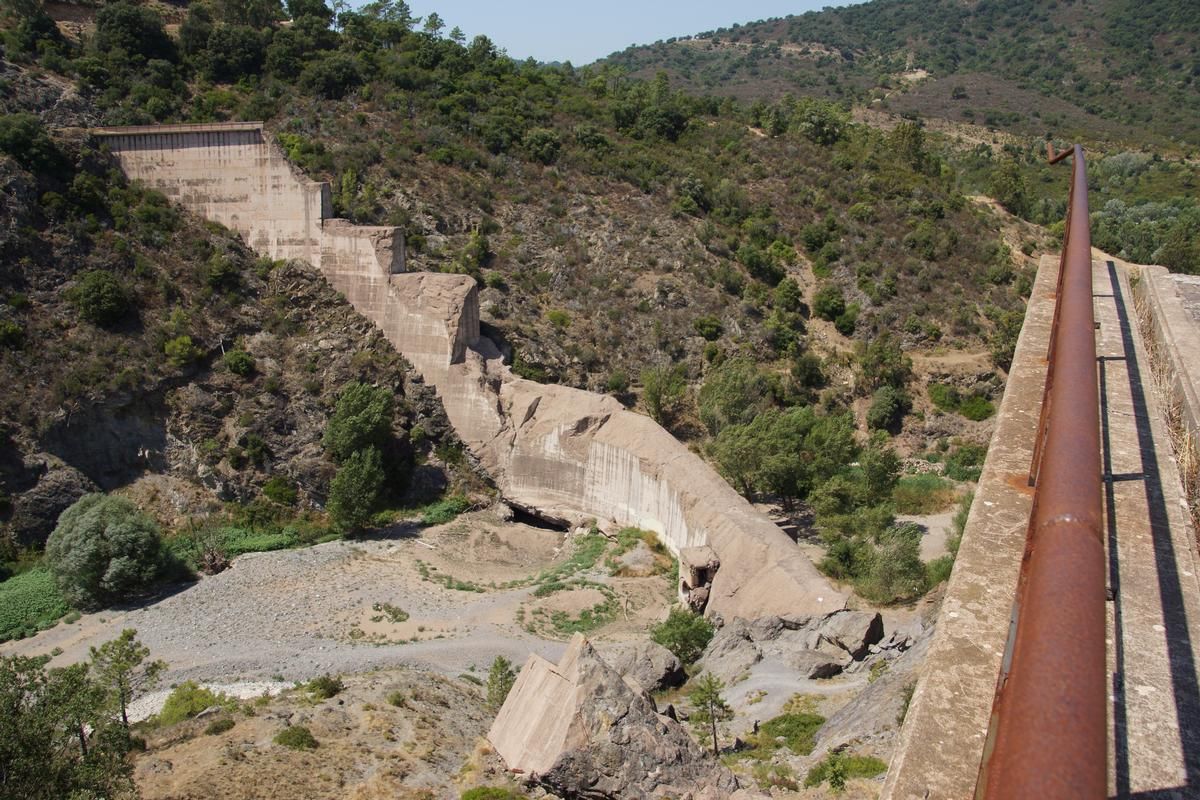
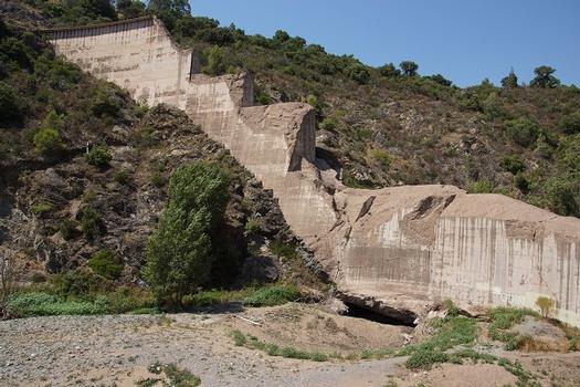
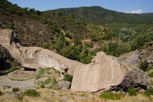
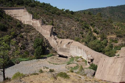
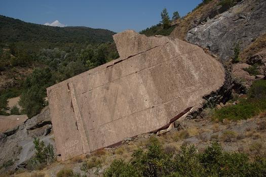
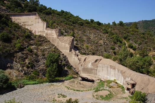
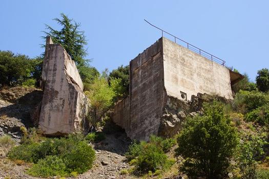
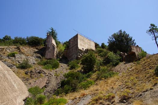
The dam was breached at 21:13 on December 2, 1959. This was partially due to the water level in the dam rising at a fast pace due to rainfall, and by noon on 2 December 1959 the reservoir had reached its maximum level. The guardian André Ferro asked for permission to release the excess water and was denied the ability to do so until 6pm of that day. The amount of water was by then so high that it took three hours to release only a few centimeters of water. The entire wall then collapsed with only a few blocks remaining on the right bank. Pieces of the dam are still scattered throughout the area.
The breach created a massive dam-break wave, or wall of water, 40 metres (130 ft) high and moving at 70 kilometres (43 mi) per hour, destroying two small villages, Malpasset and Bozon, the highway construction site, and in 20 minutes, still standing 3 metres (10 ft) high, reaching Fréjus. The water was recorded traveling at speeds up to 70 km/h with large chunks of the concrete wall some weighing up to 600 tons. Various small roads and railroad tracks were also destroyed, water flooding the western half of Fréjus and finally reaching the sea.
It was reported that the death toll of the dam breach was 423, with 135 children under the age of 15, 15 minors between 15 and 21 years old, 134 men, 112 women, and 27 individuals who were never identified. Additionally, 79 children were orphaned and 83 people were injured. Other damage included 155 buildings destroyed, 796 buildings damaged, and 1350 hectares destroyed, the amount of destruction totaling about 425 million euros in 2010 terms.
Some 1959 postage stamps had a flood surcharge imprinted on them, to raise money for flood victims.
Cause
Geological and hydrological studies were conducted in 1946 and the dam location was considered suitable. Due to lack of proper funding, however, the geological study of the region was not thorough. The lithology underlying the dam is a metamorphic rock called gneiss. This rock type is known to be relatively impermeable, meaning that there is no significant groundwater flow within the rock unit, and it does not allow water to penetrate the ground. On the right side (looking down the river), was also rock, and a concrete wing wall was constructed to connect the wall to the ground.
A tectonic fault was later found as the most likely cause of the disaster. Other factors contributed as well; the water pressure was aimed diagonally towards the dam wall, and was not found initially. As a consequence, water collected under a wall and was unable to escape through the ground due to the impermeability of the gneiss rock underneath the dam. Finally, another theory quotes a source stating that explosions during building of the highway might have caused shifting of the rock base of the dam. Weeks before the breach, some cracking noises were heard, but they were not examined. It is not clear when the cracking noises started. The right side of the dam had some leaks in November 1959.
Between November 19 and December 2, there was 50 centimetres (20 in) of rainfall, and 13 centimetres (5.1 in) in 24 hours before the breach. The water level in the dam was only 28 centimetres (11 in) away from the edge. Rain continued, and the dam guardian wanted to open the discharge valves, but the authorities refused, claiming the highway construction site was in danger of flooding. Five hours before the breach, at 18:00 hours, the water release valves were opened, but with a discharge rate of 40 m³/s, it was not enough to empty the reservoir in time.
Until the Malpasset incident, only four other incidents of arch-type dam breaches were recorded:
- Manitou dam, Manitou Springs, Colorado, 1924
- Moyie Dam (the Eileen Dam), Moyie Springs, Idaho, 1925
- Lake Lanier, North Carolina, 1926
- Purisima dam, California, 1930
Text imported from Wikipedia article "Malpasset Dam" and modified on 1 December 2020 according to the CC-BY-SA 3.0 license.
Participants
Structural engineering
-
Coyne & Bellier
- André Coyne (designer)
Relevant Web Sites

Relevant Publications
- (1967): Le barrage de Malpasset. In: Travaux, n. 389 (July 1967), pp. 363.
- (1999): The Hydraulics of Open Channel Flows. An Introduction. Edward Arnold, London (United Kingdom), pp. 512.
- About this
data sheet - Structure-ID
20000335 - Published on:
17/08/1999 - Last updated on:
29/07/2014
Structurae cooperates with


